

6th Class Social Studies – Maps Best Notes
→ We use maps when we want to study the Earth horizontally as a part, such as a country, state, district, town, village, and world as a whole.
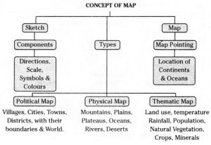
→ A rough drawing drawn without scale and directions mainly based on memory and spot observation and not to scale is called a sketch.
→ A map is a representation of the whole Earth or a part of it, on a flat surface according to ^proportionate scale. –
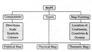
→ A map must have certain components like direction, scale, symbols, etc.
→ Main components of a map. 1.Directions 2. Scale 3. Symbols 4.Colours.
→ North, South, East, and West are called Cardinal directions. Among these four direc¬tions North is treated as principal direction. So all the maps contain a North arrow with the letter N at the top right-hand corner.
→ intermediate directions are North-East (NE), South-East (SE), South-West (SW), and North-West (NW). We can locate any place more accurately with the help of these intermediate directions.
6th Class Social Studies – Maps
→ Scale is another component of a map. The scale of a map is the ratio of a distance on a map to the corresponding distance on the actual ground. A scale can be used to figure out the distance between two locations on a map.
→ With the use of these symbols, maps can be drawn easily. With the symbols, maps are simple to read. Symbols give a lot of information in a limited space. Even if we don’t know the language of an area we can know the information from maps with the help of symbols.
→ The colors used in the maps represent different physical features.
→ Maps can be classified into three types. They are :
- Political Maps
- Physical Maps
- Thematic Maps
→ Political maps show villages, cities, towns, districts, states, and countries with their boundaries.
→ Large landmasses on the World map are called Continents. Large water bodies on the World maps are called Oceans.
→ Physical maps show the physical features such as Mountains, Plateaus, Plains, Oceans and Rivers, Deserts, etc.
→ Thematic maps show the distribution of specific features such as land use, temperature, rainfall, population, soils, natural vegetation, crops, minerals, industries, railways, roads, waterways, etc.
→ There are two types of maps based on scale.
6th Class Social Studies – Maps
- Large-scale maps
- Small-scale maps
→ Large-scale maps: These maps represent small areas. They can be divided into Cadastral maps and Topographical maps. Cadastral maps show the individual property. Topographical maps show detailed surface features.
→ Small-scale maps: They represent large areas – World, Continents or Countries. They are of two types:
- Wall maps and
- Atlas maps.
→ Map: Diagrammatic representation of an area of land or sea showing physical features, cities, roads, etc.
→ Sketch: Drawing based on memory and spot observation and not to scale.
→ Plan: Drawing a small area on a Large scale.
→ Scale: Ratio between the actual distance on the ground and the distance shown on the map with the help of scale.
→ Cardinal directions: Directions of North, East, South, and West, denoted by N, E, S, W.
6th Class Social Studies – Maps Best Notes
→ Intermediate directions: Direction between to cardinal directions (northeast, southeast, southwest, and northwest)
→ Compass: Drawing circles and arcs and measuring distances between points.
6th Class Social Studies – Maps
Links
10th Class Maths Notes Chapter 1 Real Numbers
The Food we Need AP 6th Class Science Chapter 1 New and Best Notes.
Natural Resources- AP Class 10 Biology New Notes
Our environment Our concern – AP Class 10 Biology New Notes
AP Class 10 Respiration Notes | Biology Notes | New & Best
My Class Notes- For 2020 Text Books-New & Best answers
Mallika Goes to School -New 5th Class English Unit-1- Best Answers
Light of reflection and refraction Notes New and Best for IIT Foundation