


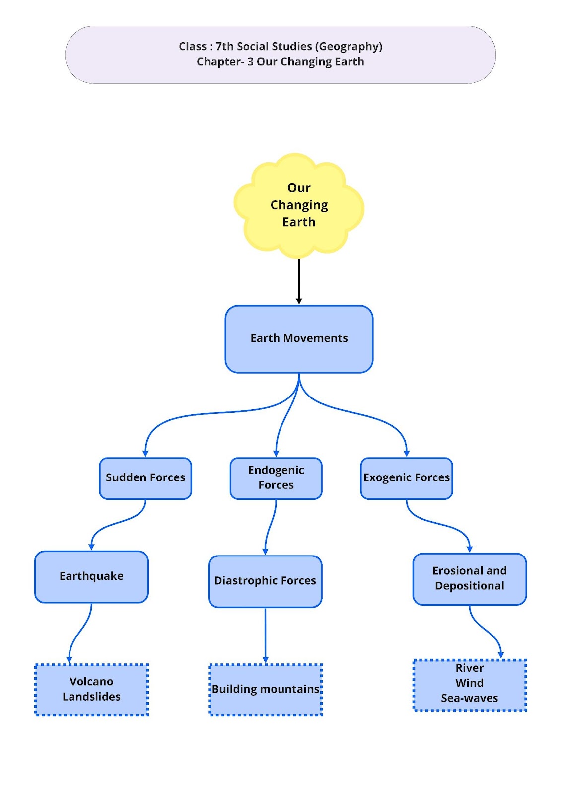
OUR CHANGING EARTH
Movements inside the Earth
The lithosphere is broken up into many plates known as lithospheric plates. These plates move very slowly due to the circular movement of the molten magma inside the surface of the Earth. These movements of the plates cause changes on the Earth’s surface. These movements of the Earth are caused due to two forces:
Endogenic forces: The forces that act in the interiors of the Earth are known as Endogenic forces. These forces may produce sudden or slow movements. Earthquakes, volcanoes and landslides are caused due to endogenic forces.
Exogenic Forces: The forces which work on the surface of the Earth are known as exogenic forces. The formation of various landforms on the surface of the Earth is the results of these forces.
Volcano :
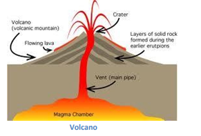
- Volcano is a vent or an opening in the Earth’s crust.
- Since the interior of the Earth is extremely hot, the immense heat and pressure melts the rock into magma.
- This magma collects in the magma chamber and tries to push itself out through a vent on to the surface of the Earth.
- This results in the eruption of a volcano. The hot magma which flows out of a volcano is called lava.
Earthquake :
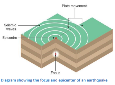
- An earthquake is caused due to the movement of the lithospheric plates inside the surface of the Earth.
- As these plates move, the surface of the Earth vibrates. The vibrations can travel all round the Earth.
- These vibrations are called earthquakes.
- The place in the Earth’s crust where the movement of the lithospheric plates first starts is called the focus of the earthquake.
- The place on the surface above the focus is called the epicentre.
- It is from the epicentre that vibrations in form of waves travel outwards. These are known as seismic waves.
- Greatest damage and destruction of human lives and property takes place on the places which are closest to the epicentre.
- The strength of an earthquake decreases as it moves away from the epicentre.
- Earthquakes cannot be predicted. However, through some methods such as study of the behaviour of animals, or agitation of fish in a pond or the coming out of snakes on to the surface, that local people may predict the occurrence of an earthquake.
Measuring of the earthquake :
- An earthquake can be measured with the help of a machine known as the seismograph. The magnitude or intensity of an earthquake is measured on the Richter scale.
- An earthquake measuring up to 6 and above on the Richter scale is considered to be very serious and can cause large scale destruction of life and property.
- An earthquake up to 5 on the Richter scale can make things fall and an earthquake up to 2 can be felt only for few seconds.
Movements on the Surface of the Earth
While volcanoes and earthquakes are caused due to the movements taking place inside the surface of the Earth, various landforms such as valleys are formed due the movements which take place on the surface of the Earth.
The surface of the Earth is worn by two processes- weathering and erosion. Weathering can be defined as breaking of the rocks on the surface of the Earth. Erosion is the process of wearing away of the surface of the Earth by the agents of erosion, i.e. water, wind and ice. The eroded materials are transported and deposited by the agents of erosion. This process creates various landforms on the Earth.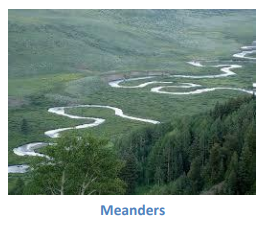
Work of a River :
- The running water of the Earth acts as an eroding agent.
- When a river flows down at a steep angle over very hard rocks or down a steep valley side, it forms a water fall. The highest waterfall in the world is Angel Falls in Venezuela in South America. The Niagara Falls located on a border of U.S.A. and Canada is another famous waterfall.
- When a river flows through the plains, it twists and takes a sudden turn to form a large loop known as a meander.
- Due to continuous erosion and deposition on the sides of a meander, the loops of the meander come closer. After sometime, the loop formed bythe meander gets completely cut off from the river and forms a cut-off lake or an ox-bow lake.
- Many a times, a river overflows its banks resulting in floods in the nearby areas.
- Due to the flooding, many layers of fine soils called sediments are deposited onto the bank of the river.
This results in the formation of fertile floodplains. The banks of the rivers get slightly elevated due to the deposition of sediments. The raised fertile banks are known as levees.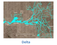
- As a river approaches the sea, the flow of water decreases and the river gets divided into many streams known as distributaries.
- As the speed of the river becomes too slow, it begins to deposit various sediments. Each distributary forms its own mouth. The sediments which are collected from all the mouths of the distributaries form a delta.
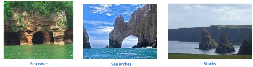
Sea Waves :
- Sea waves form various coastal landforms due to their erosion and depositional works.
- As the sea waves continuously strike the rocks, the latter develop cracks which become larger and wider over a period of time.
- Sometimes, hollow caves are formed from the rocks and are known as sea caves.
- Sea arches are formed when the caves becomes so hollow that only the roof of the caves remain.
- Further, when the sea waves break the roof and only the walls remains, they are called stacks.
- The steep rocky coast which rises almost vertically above the sea water is known as a sea cliff.
- Beaches are formed when the sea waves deposit sediments along the shores.
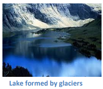
Work of Ice :
- Glaciers are large masses of snow which erode the landscape by crushing soil and stones lying beneath them and expose the solid rock on the surface.
- The rock starts cracking and at times becomes hollow due to the movement of the glaciers.
- As ice in the glacier melts, it fills these hollow structures of rock with water resulting in the formation of lakes.
- As glaciers carry materials such as big and small pieces of rocks, sand and silt get deposited. These deposits result in the formation of glacial moraines.
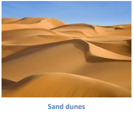
Wind as an Agent of Erosion :
- Wind is an active agent of erosion in the desert regions.
- Winds sometimes erode the lower parts of rocks more than the upper parts resulting in the formation of mushroom rocks.
- When winds blow at a great speed, they lift and transport materials from one place to the other.
- During this process, the sand falls and get deposited forming low hill kind of structures. These are known as sand dunes.
- The wind carries the extremely fine and light grains of sand to far off places. These grains of sand get deposited in large areas and are called loess. Large deposits of loess are found in China.
Important Questions
- Multiple Choice Questions:
Question 1. The earth’s crust is broken into a number of huge parts. They are called
(a) lithospheric plates
(b) metamorphic plates
(c) sedimentary plates
(d) none of these
Question 2. ____ movements like earthquakes and volcanoes cause mass destruction over the surface of the earth.
(a) Slow
(b) External
(c) Sudden
(d) Erosional
Question 3. Which is caused by the sudden movements of the earth?
(a) Volcano
(b) Folding
(c) Flood plain
(d) All of these
Question 4. Which one of the following forces originates in the interior of the earth?
(a) Exogenic forces
(b) Endogenic forces
(c) Both (a) and (b)
(d) None of these
Question 5. An earthquake is measured with a machine called a
(a) Theismograph
(b) Heismograph
(c) Seismograph
(d) Meismograph
Question 6. Where are Mushroom rocks are found?
(a) Deserts
(b) River valleys
(c) Glaciers
(d) Sea cliff
Question 7. Sudden movements in the earth are called
(a) earthquakes
(b) building mountains
(c) focus
(d) none of these
Question 8. The place in the crust where the movement starts is called the
(a) Waves
(b) Focus
(c) Epicentre
(d) Crust
Question 9. What is known as the steep rocky coast rising most vertically above the sea water?
(a) Sea cliff
(b) Glaciers
(c) Sea waves
(d) Stacks
Question 10. The place on the surface above the focus is known as
(a) epicentre
(b) focus
(c) forces
(d) lithosphere
Question 11. Which of the following rivers does not form a delta?
(a) Godavari
(b) Mahanadi
(c) Narmada
(d) Krishna
Question 12. Where is the Angel falls located?
(a) South Africa
(b) South America
(c) South India
(d) None of these
Question 13. What is the name of the instrument used for measuring earthquake?
(a) Thermometer
(b) Seismograph
(c) Weighing machine
(d) All of these
Question 14. A massive earthquake hit Bhuj Town on
(a) 16th December 2001
(b) 26th January 2004
(c) 26th January 2001
(d) 16th December 2004
Question 15. What do you mean by a glacier?
(a) Moving of Layer of earth
(b) Moving of Soil
(c) Moving of ice
(d) None of these
- Fill in the blanks:
- An earthquake is measured with a machine called ______.
- The lithosphere is broken into a number of plates known as the _________ plates.
- The _______ forces act in the interior of the earth.
- The _______ forces work on the surface of the earth.
- When the _________ plates move, the surface of the earth vibrates.
- Write true (T) or false (F):
- The molten magma inside the earth moves in a circular manner.
- Beach is an erosional feature of sea waves.
- Moraine is a depositional feature of a glacier.
- Volcano is caused by the sudden movements of the earth.
- The strength of the earthquake increases away from the centre.
- Very Short Questions:
- Define focus.
- What is vent?
- What do you know about the lithospheric plates?
- How do the lithospheric plates move?
- What is a volcano?
- Define focus’ and ‘epicentre’.
- What is a seismograph?
- Which earthquake is classified as a major earthquake?
- Where is Victoria Falls located?
- What is a delta?
- Short Questions:
- What do you mean by lithospheric plates?
- Name the two types of tectonic movement.
- What are volcanoes?
- Where are the volcanoes found?
- What is an earth quake?
- Long Questions:
- How man is also responsible for earth quake?
- Mention the work of ice.
- What is earthquake? What are some common earthquake prediction methods?
- Give an account of earthquake preparedness.
- Explain the work of a river.
ANSWER KEY –
- Multiple Choice Answer:
- (a) lithospheric plates
- (c) Sudden
- (a) Volcano
- (b) Endogenic forces
- (c) Seismograph
- (a) Deserts
- (a) earthquakes
- (b) Focus
- (a) Sea cliff
- (a) epicentre
- (c) Narmada
- (b) South America
- (b) Seismograph
- (c) 26th January 2001
- (c) Moving of ice
- Fill in the blanks:
- seismograph
- lithospheric
- endogenic
- exogenic
- lithospheric
- Write true (T) or false (F):
- True
- False
- True
- True
- False
- Very Short Answer:
- The place in the crust where the movement starts is called the focus.
- The narrow opening of a volcanoes is called vent.
- The earth’s crust consists of several large and some small, rigid, irregularly— shaped plates, Le., slabs which cany continents and the ocean floor.
- They move around very slowly, just a few millimeters each year.
- A volcano is a vent or opening in the earth’s crust through which molten material erupts suddenly.
- The place in the crust where the movement starts is called the ‘focus’. The place on the surface above the focus is called the ‘epicentre’.
- A seismograph is a machine which measures an earthquake.
- An earthquake of 7.0 magnitude is classified as a major earthquake.
- Victoria Falls is located on the borders of Zambia and Zimbabwe in Africa.
- The collection of sediments from all the mouths forms a delta. It is triangular shaped landmass.
- Short Answer:
- The solid crust of the rocks forming the surface of the earth is known as Lithosphere. The lithosphere is broken into a number of plates. These plates are known as lithospheric plates.
- Vertical earth movement and horizontal earth movement are the two kinds of tectonic movement.
- A volcano is an opening in the earth’s crust which allows hot molten rock, ash and gases to escape from below the surface.
- Volcanoes are generally found where tectonic plates are pulled apart or come together. Volcanoes can also form where there is stretching and thinning of earth’s crust, such as in the (African) rift valley.
- When the lithosphere plates moves, the surface of the earth vibrates. The vibration can travel all around the earth. These vibrations are called earth quake.
- Long Answer:
- Officially, there is such an area of research devoted to man made earth quake. Geologist and seismologist agree that humans can induce earthquake in five major ways of fluid injection into the earth, fluid extraction from the earth mining, nuclear testing and through the construction of dams and reservoirs. In fact, there are officially recorded instances of earth quake caused by human activity.
- Glaciers are rivers of ice which erode the landscape by destroying soil and stones to expose the solid rock below. Glaciers carve out deep hollows. As the ice melts they get filled up with water and become beautiful lakes in the mountains. The material carried by the glacier such as rocks big and small, sand and silt gets deposited. These deposits form glacial moraines.
- When the lithospheric plates move, the surface of the earth vibrates. The vibrations can travel all round the earth. These vibrations are called earthquakes. Some common earthquake prediction methods include studying animal behaviour, fish in the ponds get agitated, snakes come to the surface.
- Earthquake is a natural calamity which we cannot stop. But we can minimise its impact if we are prepared before-hand. During an earthquake, we should shift to some safe spot. We should hide under a kitchen counter, table or desk against an inside comer or wall. We should stay away from fire places, areas around chimneys, windows that shelter including mirrors and picture frames. Moreover, we should spread awareness amongst our friends and family members.
- The running water in the river erodes the landscape. When the river tumbles at steep angle over very hard rocks or down a deep valley side it forms a waterfall. While entering the plain the river twists and turns and forms large bends which are known as meanders. Due to continuous erosion and deposition along the sides of the meander, the ends of the meander loop come closer and closer. In -due course of time the meander loop cuts off from the river and forms a cut-off lake, which is also called ox-bow lake. Sometimes, the river overflows its banks causing flood in the neighbouring areas. As it floods, it deposits layers of fine soil and other material called sediments along its banks. As a result—fertile floodplain is formed. The raised banks are called levees.
As the river approaches the sea, the speed of the flowing water decreases and the river begins to break up into several streams known as distributaries. Then a time comes when the river becomes very slow and it begins to deposit its load. Each distributary forms its own mouth. The collection of sediments from all the mouths forms a delta, which is a triangular landmass.