
6th Class Social – Land Forms – Andhra Pradesh
→ Jana Gana Mana’ is the national anthem of our country, it describes the glory of our country. It Was written by Rabindranath Tagore.
→ ‘Ma Telugu Thalliki malle Poodanda… is our state song. “It describes the rivers and the rich heritage of our state. The shapes of the surface of the earth are called landforms. The lifestyle, food habits, and dressing patterns are different according to the region”
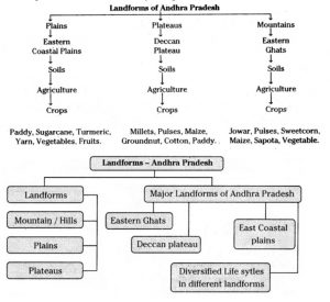
→ Landforms may vary from high elevated to plain land even valleys. Landforms can be mainly categorized into Plains, Plateaus, and Mountains or HiUs.These main landforms may contain several micro landforms. The height of the landforms is measured from Mean Sea Level (MSL).
→ A mountain is a natural higher elevated feature of the earth’s surface. Some mountains are even higher than the clouds. As we go higher and higher altitudes of mountains, the climate becomes cold. India has several huge mountain ranges like the Himalayas. In Andhra Pradesh state majority of high landforms are hills.
→ A plateau is an elevated flat land. It is a flab-topped table land standing above the surrounding area. A plateau may have one or more sides. The Deccan plateau in India is the oldest plateau and it is of volcanic origin. The larger part of Rayalaseema comes under the Deccan plateau region.
6th Class Social – Land Forms – Andhra Pradesh
→ Plateaus are rich in mineral deposits. Many of the mining areas are located in the plateaus. The Deccan plateau is a lava plateau. The lava plateaus are rich in black soil that are fertile and good for the cultivation of cotton. Many plateaus have scenic spots and are great tourist attractions.
→ Plains are level lands with flat surfaces which have a maximum height of 200 meters above sea level.
→ Andhra Pradesh is located in the east coastal line of India. It is the seventh-largest state in India in the area and the tenth most populous state. The length of the coastal line of Andhra Pradesh is 972 km.
→ Andhra Pradesh comprises – Coastal Andhra Pradesh and Rayalaseema. Coastal Andhra Pradesh has 9 districts along the coast. This region has the fertile soils of Godavari, Krishna, and Penna Delta and the density of population is very high. Rayalaseema has 4 districts in the southern region of the state and is rich in minerals and horticulture crops. This has become a horticulture hub.
→ In Andhra Pradesh, most of the high’ elevated areas are in the form of hill ranges. In our state YSR Kadapa, East and West Godavari districts, Visakhapatnam, Chittoor, Kurnool, and Vizianagaram districts have stretches of hilly terrain.
→ Arma Konda (Zindagada) in Araku valley is the highest peak in our state with 1690 meters. Borra caves of Visakhapatnam district and Papikondalu of East and West Godavari districts are the famous tourist places in these landforms.
6th Class Social – Land Forms – Andhra Pradesh
→ Lammasingi / Lambasingi, the interior tribal hamlet in Chintapalli Mandal of Visakhapatnam agency, has recorded single-digit temperatures in the winter. It is also known as ‘Kashmir of Andhra Pradesh’.
→ In hilly areas, the soils are uneven and sloped. These soils are red and rocky. Due to their high elevation and the natural downward movement of water, the soils are mostly well-drained and suitable for the plantation of beverage crops like Coffee and Tea.
→ Product is an ancient tribal agricultural practice in the hilly regions. It is also called Shifting or Jfiuming cultivation.
→ The plateau area of Andhra Pradesh belongs to the eastern Deccan Plateau and Rayalaseema region comes under this landform. Here low and uncertain rainfall and many times rain failure is a common feature. So. this area is a drought-prone region. The saline soils of plateau areas also contain more lime and salt which are unsuitable for cultivation.
→ In Andhra Pradesh, the plains are situated in coastal districts. These are stretching from Srikakulam district in the North to SPSR Nellore district in the South. These are known as coastal plains. In Andhra Pradesh, two main rivers Godavari and Krishna form a very big plain in the form of a delta.
6th Class Social – Land Forms – Andhra Pradesh
→ The delta plains are treasure houses for food grains and are called rice granary of South India. The entire plain area in Andhra Pradesh is a gift to agriculture and farmers. Here the main occupation is agriculture and more than one crop can be cultivated in major parts of the plain, regions.
→ Landform: Is a natural feature on the Earth’s surface
→ Terrain: A stretch of land, especially with regard to its physical features
→ Agent: A person who acts on behalf of another person or group
→ Spring: A spring is a point at which water flows from an aquifer to the Earth’s surface
→ Drought: Prolonged shortage of water due to less rainfall
6th Class Social – Land Forms – Andhra Pradesh
→ Drought prone area: The areas which are often hit up by droughts
→ Alluvial Soils: The soils formed with silt brought by rivers, very fertile lands
→ Orchards: Fruit gardens
→ Uplands: A little bit of high land in plain areas
→ Tenancy: The period of time for which a person has the right to use a piece of land
→ Juga: It is a tree grown in hilly areas. Caryota (the scientific name of Telugu) is a genus of palm trees.
6th Class Social – Land Forms – Andhra Pradesh
→ Drought-hit: The area affected by drought
Links
10th Class Maths Notes Chapter 1 Real Numbers
The Food we Need AP 6th Class Science Chapter 1 New and Best Notes.
Natural Resources- AP Class 10 Biology New Notes
Our environment Our concern – AP Class 10 Biology New Notes
AP Class 10 Respiration Notes | Biology Notes | New & Best
My Class Notes- For 2020 Text Books-New & Best answers
Mallika Goes to School -New 5th Class English Unit-1- Best Answers
Light of reflection and refraction Notes New and Best for IIT Foundation
Errors and Types of Errors – Inter Physics